 Nautical Charts v.1.0.0.0
Advertisement
Description
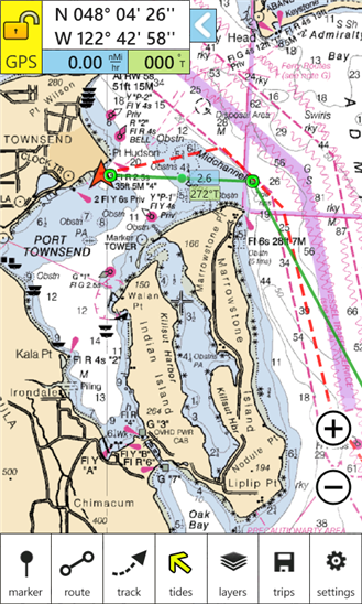
NOAA nautical charts with animated tides and currents, markers, routing, and tracks. Charts cover the entire USA coastline. Use GPS to map your location, plan a course, mark locations, and show tides and currents.
- Rate:
- Release Date:09/14/2012
- License:Shareware
- Category:Recreation
- Developer:Nomad Electronics
- Downloads:71
- Size:1024 Kb
- Price: $9.99
To free download a trial version of Nautical Charts, click here
To visit developer homepage of Nautical Charts, click here
Advertisement
Screen Shot
Click on a thumbnail for the larger image.
System Requirements
Nautical Charts requires Windows Phone 7.5 or higher | location services, photo, music, and video libraries, data services, HD720P (720x1280), WVGA (480x800), WXGA (768x1280) | English (United States)
Nautical Charts v.1.0.0.0 Copyright
Shareware Junction periodically updates pricing and software information of Nautical Charts v.1.0.0.0 full version from the publisher using pad file and submit from users. Software piracy is theft, Using crack, password, serial numbers, registration codes, key generators, cd key, hacks is illegal and prevent future development of Nautical Charts v.1.0.0.0 Edition. Download links are directly from our publisher sites. Links Nautical Charts v.1.0.0.0 from Bittorrent, mediafire.com, uploadfiles.com, hotfiles.com rapidshare.com, megaupload.com, netload.in, storage.to, depositfiles.com and other files hosting are not allowed. The download file is obtained directly from the publisher, not from any Peer to Peer file sharing applications such as Shareaza, Limewire, Kazaa, Imesh, eDonkey, eMule, Ares, BearShare, Overnet, Morpheus, BitTorrent Azureus and WinMX.
Review This Software
More Nautical Charts Software
Advertisement


Navigator (free) v.7.4.0.0
Thinking about that next sailing trip? Navigator measures distance and bearings without having to pull out the charts, dividers and parallel rulers. Just enter points on the map and let your phone do all the measurement for you! Navigator calculates

Navigator v.7.4.0.0
Thinking about that next sailing trip? Navigator measures distance and bearings without having to pull out the charts, dividers and parallel rulers. Just enter points on the map and let your phone do all the measurement for you! Navigator calculates
Outdoor Navigator v.1.2
About Outdoor Navigator- Maps and Charts for Handheld PDAsa€“ Palms, Pocket PCs, Smart Phones Hike, Boat, Fish, Explore the USA- Detailed Maps via the Internet from Maptech a€“Under $100a€“ GPS Readya€“ Hi-Tech Outdoor Navigation Made Easy a€“ Over 6
Eye4Software GPS Mapping Studio v.4.1
GPS Mapping Software for Windows, Loading topographic maps, Realtime navigation, GPS position tracking, Map import and export, Coordinate conversion and more
DeepView SE v.2 2
DeepView SE is a complete powerful environment for recording and reviewing side scan sonar files. Main features: -Ping return and GPS position recording. -Waterfall view with distance measure, target height measure and more. -Zoom in window.
Hydromagic v.4.1.12.315
Eye4Software Hydromagic is a hydrographic survey program tool, which can be used to map areas using a GPS and echosounder. Use the program to import, view and edit your maps, display your position and to record depths.
Fugawi Global Navigator v.4.5.50.5002
Fugawi is a strong bitmap-to-use maps in combination with a GPS receiver. Fugawi offers the capability to calibrate with precision digital maps or scan paper maps. You can also import a large number of official or commercial mapping products.
2010 Nautical Almanac v.1 10
Complete 2010 Nautical Almanac in pdf format.
MB Vedic Astrology Divisional Charts
MB Vedic Astrology Divisional Charts is an advanced yet simple software based on the principles of Indian Astrology. It gives an insight into the Rashi Chart of a person along with his/her Divisional Charts. The Vedic Divisional Charts or the Vargas is
Amazing Charts v.6.0.10
The Amazing Charts Electronic Health Record (EHR) system is designed to match your office flow - including scheduling appointments, instant messaging throughout the day between you and your staff, documenting notes, patient phone calls, etc.
Other products of this developer Nomad Electronics
Pocket Stars v.6 1
Pocket Stars PC is a high accuracy star chart an...h capabilities with simple and quick navigation.